Landscape habitat and weather influence wetland birds
Landscape habitat variables can influence wetland breeding birds’ occupancy of an area. This research examines the effects of landscape habitat variables on wetland birds in the Prairie Pothole Region of the United States.
Background
Scientists studying bird habitat preferences often focus on vegetation within a territory or home range. These relationships are considered small-scale effects because they occur in proximity or within the small area where birds spend day-to-day activities (i.e., foraging, nesting, resting). However, recent studies suggest that habitat factors may influence birds at much larger scales within 1,000, 10,000, or 100,000 hectares surrounding a bird’s territory or home range. These relationships are called landscape effects because they are thought to operate at much larger scales beyond where a bird conducts day-to-day activities.
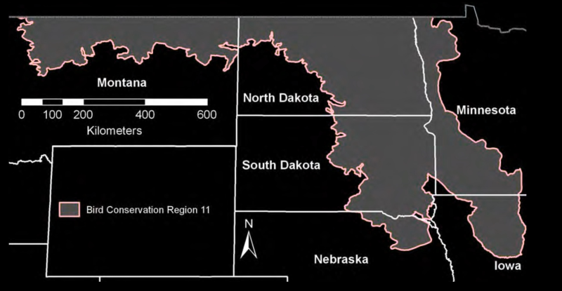
My PhD dissertation examined the effects of landscape habitat variables on ten species of wetland breeding birds in the Prairie Pothole Region of the United States (Figure 1). The goal was to use models to predict relative abundance across the landscape based on surrounding habitat features. These models can predict where animals are most likely to be in high abundance, so any management techniques can be directed to these areas to achieve optimal benefit.
Methods
I used existing data sets from the North American Breeding Bird Survey, the National Landcover Database, and the National Climate Data Center to build models to predict bird abundance for ten bird species. These species include:
| Ducks and Grebes | Terns and Raptors | Songbirds |
|---|---|---|
| Mallard | Northern Harrier | Marsh Wren |
| Blue-winged Teal | Black Rail | Red-winged Blackbird |
| Ruddy Duck | Yellow-headed Blackbird | |
| Pied-billed Grebe | Common Grackle |
I built a suite of models for each species using known habitat and weather relationships from the literature. Each variable in the models was quantified across the Prairie Pothole Region in GIS at a 1,000, 10,000, and 100,000-hectare scale around each Breeding Bird Survey route.
I fit the models for each species in a Bayesian framework and controlled for temporal, spatial, and observer effects so I could evaluate the effects of habitat and climate without these nuisance factors. Next, I assessed the performance of each model relative to every other model in the candidate set for each species. Finally, I used the best model for each species to make a predictive map of abundance across the entire Prairie Pothole Region.
I evaluated the best model using approximately 20% of the data withheld when I initially fit each model in the species-specific candidate set. This 20% of data not used when model fitting is meant to serve as an independent dataset for evaluating the models’ performance. The results of this evaluation are covered in more detail in the following studies on waterbirds, terns and raptors, and blackbirds.
I generated maps of predicted relative abundance for each species, showing areas of lower to higher abundance. Then, based on the model fitting, I mapped each variable at the scale which it was important (1,000 ha, 10,000 ha, and 100,000 ha).
Results
Ducks and Grebes
The strongest positive influences on ducks and grebes were the percentage of wetland at all three spatial scales, herbaceous vegetation, and precipitation variables. Mallards are expected to be most abundant in central North Dakota and northeastern South Dakota. Small areas in north-central Montana also were predicted to contain high numbers of mallards (Figure 2). Blue-winged Teal abundance is expected to be highest in central North Dakota and north-central South Dakota, with lower abundance elsewhere (Figure 3). Ruddy ducks were most concentrated in south-central North Dakota and north-central South Dakota (Figure 4). Pied-billed grebes showed scattered high concentrations of predicted abundance occurring in central North Dakota and northeastern South Dakota, with lower abundances occurring elsewhere in the Prairie Pothole Region (Figure 5).
Raptors and Terns
The strongest influences on the abundance of these two species were the percentage of wetland area across all three spatial scales and precipitation from the previous year. Northern Harrier abundance was predicted to be highest in central North Dakota and eastern South Dakota, with low abundance in the eastern portion of the Prairie Pothole Region (Figure 6). Black Tern abundance was most concentrated in central and northeastern North Dakota and northeastern South Dakota, with lower abundances predicted elsewhere in the Prairie Pothole Region (Figure 7).
Songbirds
Maps of Marsh Wren abundance showed scattered high abundance in eastern North Dakota and northeastern South Dakota; western Minnesota also had high predicted abundances of Marsh Wrens (Figure 8). Variables with the strongest associations with blackbird relative abundance were the percentage of wetland area and precipitation amount from the previous year. The influence of spatial scale appeared small for all four species. Red-winged blackbirds were predicted to be abundant across the Prairie Pothole Region, with the highest predicted relative abundance in northwest Minnesota (Figure 9). Yellow-headed blackbirds were expected to exhibit locally high numbers throughout North Dakota and eastern South Dakota and lower relative abundances elsewhere, with minimal area in the Prairie Pothole Region predicted to have intermediate densities (Figure 10). Common grackles were predicted to be most abundant in western Minnesota and south-eastern South Dakota, with lower densities throughout the northern portion of the study area. Common grackles were also abundant in urban areas due to their tolerance for human habitation (Figure 11).
Conclusions
This research revealed new relationships between wetland bird abundance and landscape-level habitat and weather variables. These findings suggest that modeling and mapping landscape habitat and weather relationships can be valuable for predicting spatial variation in bird abundance at landscape scales. These findings and maps have two primary uses:
- Models provide insights into how wetland birds are associated with different weather and habitat variables and landscape scales, and
- Predicted abundance maps indicate locations where management actions would be optimally beneficial (areas of highest abundance). While weather cannot be managed, it is possible to manage landscape patterns to optimally benefit select species as desired.
References
Forcey, G. 2006. Landscape-level influences on wetland birds in the prairie pothole region of the United States and Canada. PhD Dissertation, North Dakota State University, Fargo, North Dakota. https://www.proquest.com/docview/305290013
Forcey, G. M., G. M. Linz, W. E. Thogmartin, and W. J. Bleier. 2007. Influence of land use and climate on wetland breeding birds in the Prairie Pothole Region of Canada. Canadian Journal of Zoology 85:421–436. https://cdnsciencepub.com/doi/10.1139/Z07-005
Forcey, G. M., W. E. Thogmartin, G. M. Linz, W. J. Bleier, and P. C. McKann. 2011. Land use and climate influences on waterbirds in the Prairie Potholes. Journal of Biogeography 38:1694–1707. https://onlinelibrary.wiley.com/doi/abs/10.1111/j.1365-2699.2011.02510.x
Forcey, G. M., W. E. Thogmartin, G. M. Linz, and P. C. McKann. 2014. Land use and climate affect black tern, northern harrier, and marsh wren abundance in the Prairie Pothole Region of the United States. The Condor 116:226–241. https://academic.oup.com/condor/article/116/2/226/5153090
Forcey, G. M., W. E. Thogmartin, G. M. Linz, P. C. McKann, and S. M. Crimmins. 2015. Spatially explicit modeling of blackbird abundance in the Prairie Pothole Region. Journal of Wildlife Management 79:1022–1033. https://wildlife.onlinelibrary.wiley.com/doi/abs/10.1002/jwmg.912